


Introduction
Whether you’re a passionate hiker, an adventurous cyclist, or someone who simply enjoys spending weekends exploring nature, having the right planning tool can completely change your outdoor experience. Outdooractive has become one of the most popular platforms for outdoor enthusiasts because it combines route planning, GPS navigation, offline maps, and community-generated trails into one easy-to-use application.
Instead of relying on multiple apps for maps, weather, and navigation, Outdooractive brings everything together. It helps users discover new destinations, create custom routes, and navigate confidently even in remote locations where internet access is unavailable.
In this guide, we’ll explore everything you need to know about Outdooractive, including its features, benefits, pricing, best uses, and why millions of outdoor lovers trust it for their adventures.
What Is Outdooractive?
Outdooractive is an all-in-one outdoor navigation and route planning platform designed for people who enjoy exploring nature. Available on both desktop and mobile devices, it allows users to discover thousands of hiking trails, cycling routes, mountain biking paths, running tracks, ski tours, and many other outdoor activities.
Unlike a standard GPS app, Outdooractive focuses specifically on outdoor adventures. It provides detailed topographic maps, elevation profiles, trail difficulty ratings, estimated completion times, and downloadable offline navigation.
The platform is popular across Europe but has expanded its coverage to many regions around the world. Whether you’re planning a short forest walk or a multi-day mountain expedition, Outdooractive provides the tools needed to prepare safely and efficiently.
Key Features of Outdooractive
One of the biggest reasons Outdooractive has gained popularity is its extensive collection of useful features. Rather than offering only navigation, it acts as a complete adventure planning assistant.
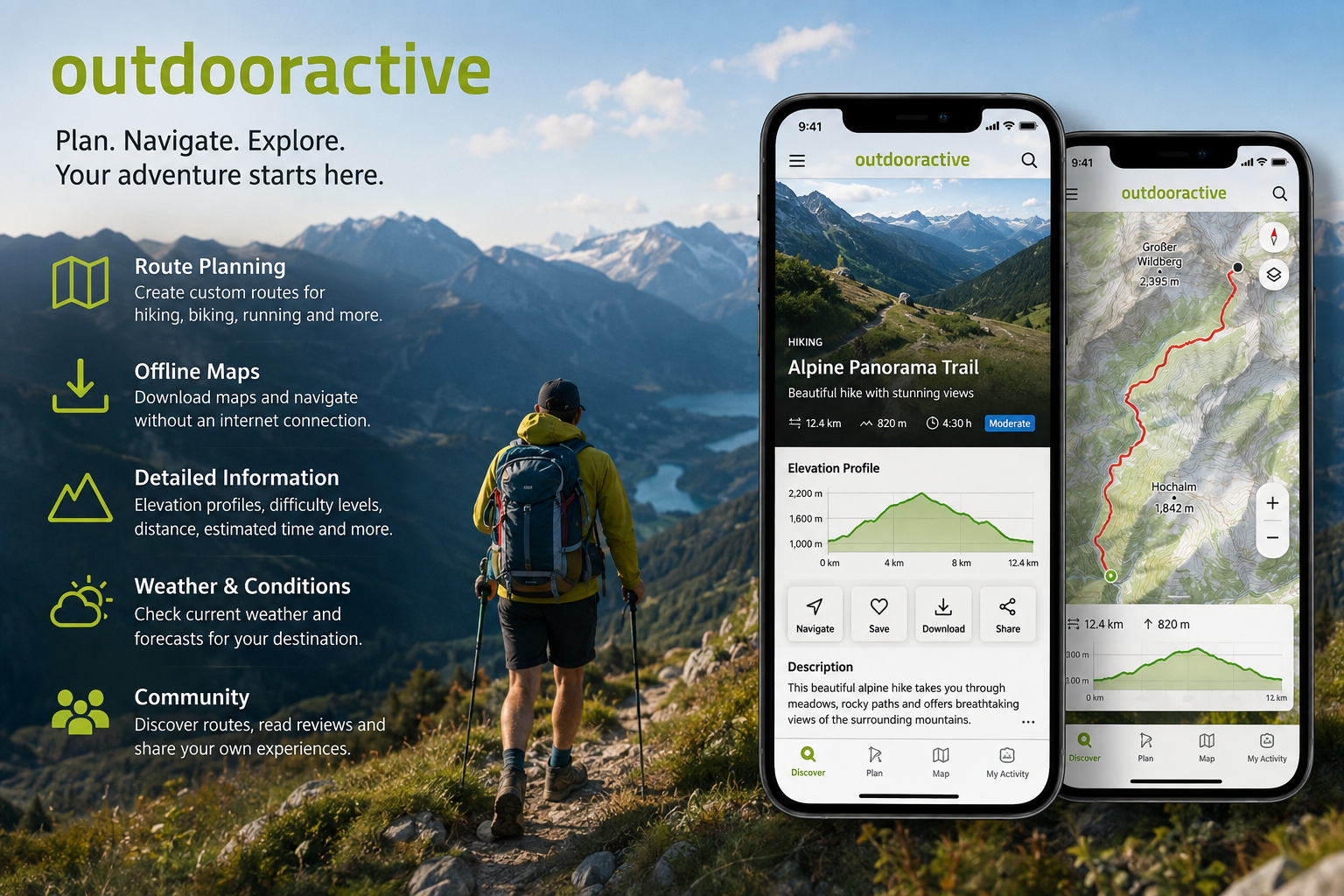
The route planner lets users build custom routes by selecting trails, roads, or paths. Elevation charts update automatically, allowing hikers and cyclists to understand how difficult a route may be before heading out. This helps avoid unexpected climbs and improves trip planning.
Another standout feature is offline navigation. After downloading maps to your device, you can continue navigating without a mobile signal. This is especially valuable in remote mountain regions, national parks, and forests where internet connectivity may be limited.
Outdooractive also includes detailed topographic maps, weather information, points of interest, accommodation listings, restaurants, mountain huts, and attractions, making trip planning much easier.
Activities You Can Plan with Outdooractive
Outdooractive isn’t designed for just one type of adventurer. It supports a wide variety of outdoor sports and recreational activities.
Hikers can discover beginner-friendly nature walks, challenging mountain hikes, and multi-day trekking routes. Cyclists have access to road cycling, gravel biking, and mountain biking trails complete with elevation profiles and route details.
Winter sports enthusiasts benefit from ski touring, snowshoeing, and cross-country skiing routes. Trail runners can also find suitable paths based on terrain and difficulty.
In addition, users can plan activities such as climbing, canoeing, camping, backpacking, walking, horseback riding, and family-friendly outdoor excursions.
This flexibility makes Outdooractive suitable for beginners, experienced adventurers, and professional outdoor guides alike.
Route Planning Made Simple
Planning an outdoor trip used to involve studying paper maps, reading guidebooks, and checking multiple weather sources. Outdooractive simplifies this entire process.
Users simply choose a destination, activity type, and preferred difficulty level. The platform instantly displays recommended routes with useful information including distance, elevation gain, estimated duration, and user reviews.
For people who enjoy creating personalized adventures, the built-in route planner allows every section of a journey to be customized. Waypoints can be added, rest stops included, scenic viewpoints marked, and alternative paths selected with only a few clicks.
After finalizing the route, users can save it, share it with friends, or download it for offline navigation before leaving home.
Offline Maps and GPS Navigation
Reliable navigation is one of the most important aspects of outdoor safety, especially when traveling through unfamiliar areas.
Outdooractive allows users to download complete maps directly onto their smartphones. Once downloaded, these maps remain available without requiring an internet connection.
During the journey, GPS tracks your location in real time and compares it to your planned route. If you accidentally leave the trail, the app makes it easier to recognize the mistake before wandering too far.
Offline navigation not only improves convenience but also increases safety in locations where mobile networks are weak or unavailable.
Community Routes and Shared Experiences
One of Outdooractive’s greatest strengths is its active community of outdoor enthusiasts.
Users regularly upload new routes, photographs, reviews, and helpful travel tips. Instead of relying only on official trail information, you also benefit from real experiences shared by people who recently completed the same journey.
Community feedback often highlights seasonal conditions, temporary closures, water availability, parking options, and hidden viewpoints that traditional maps may not include.
This collaborative approach keeps route information fresh while helping beginners gain confidence before exploring unfamiliar destinations.
Outdooractive Free vs Premium
Outdooractive offers both free and premium membership options.
The free version provides access to many popular routes, basic navigation tools, and community content. Casual users can comfortably explore local trails without paying anything.
Premium membership unlocks advanced features such as unlimited offline maps, professional route planning tools, satellite imagery, premium map layers, official topographic maps, and more detailed navigation options.
For hikers, cyclists, and travelers who spend significant time outdoors throughout the year, the premium subscription often delivers excellent value because it improves convenience and safety.
Choosing between free and premium depends largely on how frequently you explore outdoor destinations.
Benefits of Using Outdooractive
Outdooractive offers several advantages compared to traditional navigation methods.
First, it saves time during trip planning by bringing maps, routes, weather information, and navigation together in one place. Instead of switching between multiple applications, everything is available within a single platform.
Second, the route information is highly detailed. Elevation, estimated duration, terrain type, and trail difficulty help users prepare properly before beginning an adventure.
Another benefit is improved safety. Offline navigation, GPS tracking, and route guidance reduce the chances of getting lost in unfamiliar environments.
Finally, Outdooractive encourages exploration. Many users discover hidden trails, scenic viewpoints, and local attractions they would never have found using standard navigation apps.
Tips for Getting the Most Out of Outdooractive
Using Outdooractive effectively involves more than simply opening the app before your hike.
Begin by downloading offline maps while you still have a stable internet connection. This ensures uninterrupted navigation if your signal disappears during the journey.
Always review elevation profiles before selecting a route. A short trail with steep climbs may be more demanding than a longer route with gentle terrain.
Read recent user reviews to learn about trail conditions, weather impacts, or temporary closures. Community updates often provide valuable information that official guides haven’t yet included.
Carry essential outdoor equipment including water, snacks, appropriate clothing, a power bank, and a physical map for emergencies. While Outdooractive is an excellent navigation tool, responsible outdoor preparation should always remain a priority.
Is Outdooractive Worth Using?
For anyone who regularly enjoys outdoor activities, Outdooractive is undoubtedly worth considering.
Its combination of route discovery, detailed mapping, GPS navigation, and offline functionality makes it one of the most complete outdoor planning platforms available today. Beginners appreciate the simple interface, while experienced hikers and cyclists benefit from advanced planning tools and professional map options.
Although the free version is suitable for occasional adventures, serious outdoor enthusiasts may find the premium subscription worthwhile due to its expanded navigation features and offline capabilities.
Ultimately, Outdooractive helps users spend less time worrying about directions and more time enjoying nature.
Conclusion
Outdooractive has transformed how people plan and experience outdoor adventures. From discovering scenic hiking trails to building custom cycling routes and navigating remote mountain landscapes, it provides everything needed for safer and more enjoyable exploration.
Its combination of GPS navigation, offline maps, community recommendations, and advanced planning tools makes it an excellent companion for hikers, cyclists, runners, backpackers, and travelers alike. Whether you’re exploring local parks or embarking on a multi-day expedition, Outdooractive offers practical features that improve both convenience and confidence.
If you enjoy spending time outdoors, learning how to use Outdooractive effectively can make every adventure more organized, safer, and far more rewarding.